Quick Info:
Nearest Town: Clancy                                 Yearly Closure?: Oct. 15 to Dec. 2
Trail Rating: Class 3.5 Length: Primary Trail: 3 Miles / Main Loop: Approx. 8.5 Miles
High-Clearance Required: Yes Wide/Long Vehicles: Width & Length Concerns
Trail Type (Mutiple Loop Options)
|
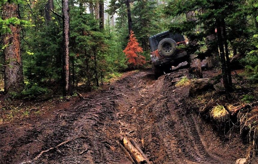
I rate this as a Class 3.5 Trail. It can be pretty easy when completely dry. However, when wetter, a few of the muddy spots can be quite challenging (read: FUN!) when really wet. It is common for newer wheelers to winch through these sections during the wet season. Hence, the 3.5 rating.
This trail is about the obstacles and the driver, not the scenery. It is not a particularly scenic or engaging trail for the kids but it is good fun for the driver.
WARNING: Due to the large amount of beetle killed trees along this trail, we recommend you have a chainsaw, bow saw or ax when traveling this trail. Both the North Quartz Creek and South Quartz Creek roads, which link to the Lave Mountain Trail, are Class 2.5 trails. If you take a right (north) turn where Lava Mountain Trail and North Quartz Creek meet, you can, depending on your choices, cross to Cataract Creek Road, to the Occidental Plateau, or to the High Ore Road and Comet. If you take a right (south) at that intersection you can loop back to the trailhead.
|
 |
| A few spots can be extra challenging when wet |
|
|
This trail has a number of obstacles that will require 4wd and at least two where a locker may be desirable, depending on the time of year, amount of mud, and which direction you choose to travel the trail.
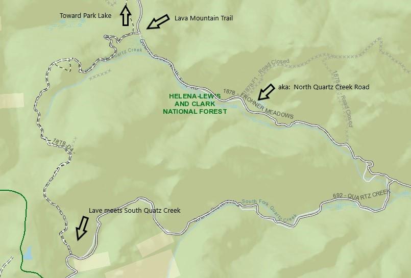
The Lava Mountain Trail is a true 4x4 trail located above Park Lake. Together with North Quartz Creek Road and South Quartz Creek Road, it makes a nice loop back to Frohner Meadows. Of course, there are a number of ways to get to the trail. Here, I will use what I think is the most common, easiest to get to, and luckily for me, the easiest to explain.
|
 |
| Lave Mountain Trail & North and South Quartz Creek Roads |
|
|
Getting there:
The Clancy exit on I-15 is exit 182. Our destination, the entrance to the Lava Mountain Trail, is about 14.8 miles from the exit.
From the exit, head west on Railroad Way toward Legal Tender Lane.
|
Continue straight onto Legal Tender Ln (past the restaurant, and onto Cutoff Rd. There is a slight left curve onto Lump Gulch Rd. - Head west on Lump Gulch Rd toward Corral Gulch Rd, then turn right onto Corral Gulch Rd. Follow Corral Gulch Road past the turnoff for Chessman Reseviour, continuing to the top of the hill. you will cross a cattle guard just after the peak of the hill. - Just past the cattle guard, the road will again fork.
|
Take the route to the right going toward Frohner Meadows. Frohner Meadows and the entrance to Lava Mountain Trail is about 3.8 miles further. Frohner Meadows will be a meadow at the peak of the hill. Lave Mountain Trail is to the right about 200 feet and North Quartz Creek is straight ahead.
Grid info for the entrance of Lava Mountain Trail:
46°25'42.6"N 112°11'30.7"W or 46.428491, -112.191854
For a Google Maps Pin of this spot **CLICK HERE**
Once you are on Lava, just stay to the main trail until you come to the T in the road as Lave meets South Quartz Creek Road.
Grid info for the end of Lava Mountain Trail. (Where it meets South Quartz Creek Road)
46°24'10.0"N 112°12'06.6"W or 46.402769, -112.201838
For a Google Maps PIN (South Quartz Creek) **CLICK HERE**
|
Of course, you can go either right or left at the junction of Lava Mountain Trail and South Quartz Creek Road. However, for our purposes, we are going to go left here, heading downhill. Continue this way for about 3.5 miles and you will run into another T in the road. This is the junction of south Quartz Creek Road and North Quarts Creek Road. Take a left here. you will be heading uphill 2.8 miles back to the junction of South Quartz Creek Road and the entrance we used for the Lava Mountain Trail.
Now just head back the same way you came in from the exit at Clancy.
That’s it. This trip makes for a pretty full day unless you are a speed junkie.
|
NOTE: We are simply describing a 4x4 route. We accept no responsibility for your decisions. 4x4 off-roading can be great fun but it can also be dangerous. People can get hurt and vehicles can get stuck and/or damaged. Trail conditions can, do, and will, change at any time. Road conditions may no longer be accurately reflected in this or any trail description. Only you can decide what trails or obstacles your experience and vehicle can safely navigate. When in doubt, turn around. Wheel Safe!!
|
|