| Connects to: Skyline Mine Trail & Radersburg Pass Loop |
| Access to Elkhorn Ghost Town |
Quick Info:
Nearest Town: Boulder                               Yearly Closure:  None
Trail Rating: Class 3.5 Length: 6.2 Miles
High-Clearance Required: Yes Wide/Long Vehicles: Width & Length Concerns
Trail Type: Loop
|
This is a great little (short) trail with a big attitude. The road, which was closed to vehicle traffic back in the early 1980s, was reopened in June of 2014. It runs from Boulder to the Elkhorn Road just south of Elkhorn MT.
This road was originally, believe it or not, a stagecoach route to Elkhorn. The Boulder side does follow the original trail, though. This is due to a landowner conflict. However, concessions weremade and a new access trail was made in cooperation with a land owner. This trail was reopened due to the hard work of a number of organizations and people who succesfully showed the trail was not legally closed and worked to both create the new section of road and to cleanup and reopen the rest.
|
 |
| Brian crosses a rock garden |
|
|
Because of this re-opening and re-routing of a small portion of the old road, it does not appear correctly on older maps (and some supposedly newer ones). While the road itself is a country road under Forest Service supervision, the lower portion of the original trail goes through sections of private land owned by two ranches, a small section of state land and borders an area of Forest Service land which is closed to motor vehicles. Please stay on the legal road and the new trail.
While the signs are constantly torn down by criminals, the landowners DO post thier lands as NO TRESSPASSING. Please respect that and stay on the main (legal) road.
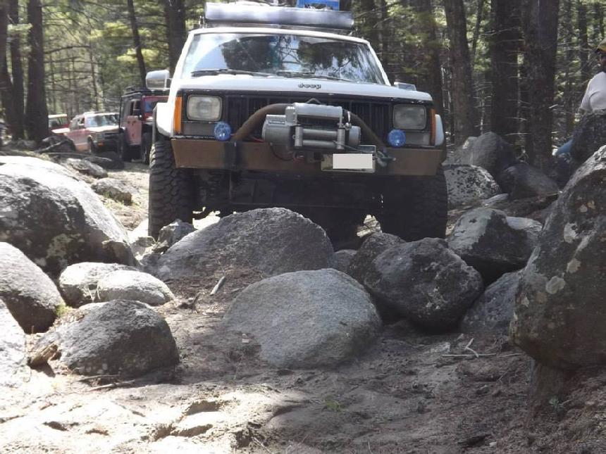
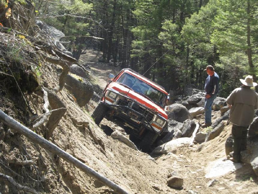
This is a Class 3.5 trail due to a few interesting rock challenges. Vehicle damage is not uncommon on this trail. The larger the vehicle, the more likely damage becomes. Rock rails or sliders are highly recommended. This is primarily due to just two spots. If careful, a stock Jeep YJ or Tacoma can make it without damage...ok, a little luck may help too.
People who are trailering their rig may wish to consider leaving the trailer at the Boulder Town Pump (get permission, of course). There is a parking area at the trailhead. It is an unimproved dirt road for part of the way, so keep that in mind.
|
 |
| The is "The Cut" on McCarty Creek Trail. It can be an interesting obstacle. |
|
|
How to get there:
Our directions start in the town of Boulder. Toward the south side of town is East 4th Avenue. Turn east here on the road which runs in front of the Jefferson High School, so go slow. East 4th Avenue continues east out of town and then curves to the right (south). At this point, the road becomes Muskrat Lane. Follow Muskrat Lane until you come to a 4-way intersection. Our path takes us straight across the intersection. The road is now McCarty Creek Road. This is where the adventure begins.
DIRECTIONS TO PARKING AREA
This is pretty simple. The parking area is 4.5 miles from the turn at the high school and 2.3 miles from the 4 way intersection at Muskrat Road. Just follow the main trail until you get to the parking area. See...I told you it was easy. This is a good spot to air down.
Parking Area Grid Coordinates and Google Maps Link:
46°14'07.0"N 112°02'18.4"W ~~OR~~ 46.235273, -112.038441
|
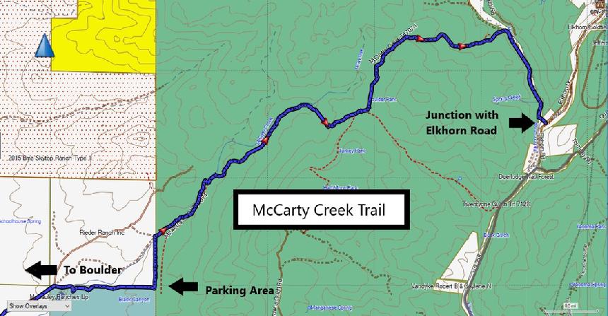 |
| McCarty Creek Trail |
|
|
The Elkhorn Road Intersection Coordinates: 46°15'27.2"N 111°57'42.2"W ~~OR~~ 46.257552, -111.961719For a Google pin link to this location: **CLICK HERE**
The trail is 6.2 miles long from the parking area to the junction with Elkhorn Road. The majority of the trail is FS Trail 1074 aka: McCarty Creek Trail. Just before you reach the Elkhorn Road, you will be on Tramway Road.
It is really a simple trail to follow, with one exception. From the parking area, you just head north through the cattle guard. The road will turn eastward just after crossing McCarty Creek. That exception? When you come to the large power lines you will need to turn right, go almost to the next tower and then turn left onto the trail heading that way.
By Richard Hiltz
|
 |
| Don always makes things look so easy. |
|
|
Please respect the private property which is on both sides of the entrance road leading to the parking area (Boulder side). The property is posted (even if people keep tearing the signs down) and you should only drive on the main road/designated route. As well, the area to the east of the parking area (and east of the "new" trail just beyond) is closed to ALL motorized access.
|
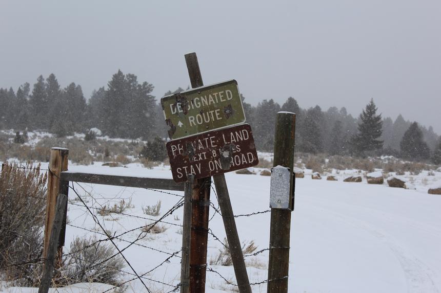 |
| Sign at entrance to McCarty Creek area |
|
|
NOTE: We are simply describing a 4x4 route. We accept no responsibility for your decisions. 4x4 off-roading can be great fun but it can also be dangerous. People can get hurt and vehicles can get stuck and/or damaged. Trail conditions can, do, and will, change at any time. Road conditions may no longer be accurately reflected in this or any trail description. Only you can decide what trails or obstacles your experience and vehicle can safely navigate. When in doubt, turn around. Wheel Safe!!
|
|