| MIDDLE FORK OF THE JUDITH RIVER |
|
The Middle Fork Of The Judith River Trail is a special place and is one of the most scenic trails I know of in Montana.
I rate it a Class 2.5 trail in the late summer and fall when the river’s levels are lower. (Class 2: Scenic, touring trail ride. Four-wheel drive required occasionally. Some mud or rocks that would stop low-clearance or 2wd vehicles but can be traveled easily in 4WD.) This means it is suitable for most standard 4x4 rigs. Width is an issue in several spots on this trail. Superduty trucks or H1 Hummers may want to skip this one. (Sorry)
The trail is about 8 miles in length and is one way in and back out. The main draw for many is the 24 river crossings as you travel each way. The river and the area are quite beautiful. There are two steep hills and some thin spots in the trail. Mud Flats can be quite interesting in the rainy months. and the water crossings are not safe until the spring runoff is over. Other than that, it is an easy trail. Elevation only changes about 525 feet across the entire trail ranging from about 5000 ft. to about 5525 ft above sea level.
|
|
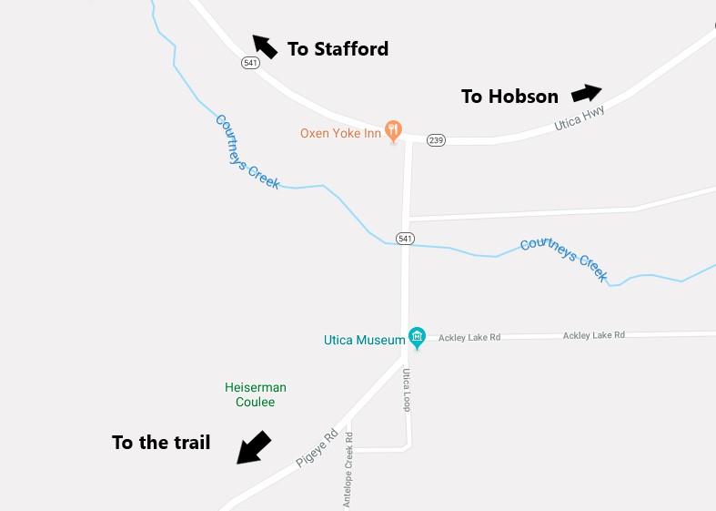
How To Get There
I will start my directions at the intersection of Montana highways 541 and 239 right at the old historic town of Utica. While there is one exception, almost everyone ends up at this point no matter which direction them come from. This intersection is about 11 miles south of Stafford or 11 miles west of Hobson Montana. The Oxen Yoke Inn is at this intersection.
|
 |
| intersection of MT 541 & MT 239 |
|
|
From the trailhead, you will just follow the main trail. This is Forest Service Road 825 (aka The Middle Fork Judith River Road). Once on the trail, there really is no chance of ending up on to another trail or road.
8 miles after the trailhead, and after 24 river crossings, you will come to a well-marked metal gate which is posted no trespassing.
This is, of course, the end of the road for us. Well, more like the beginning of the trail back.
The trail is not hard to follow. There are a few crossings where vegetation makes the trail a little hard to spot at a few crossings. Just stop and look and you will see them.
|
|


