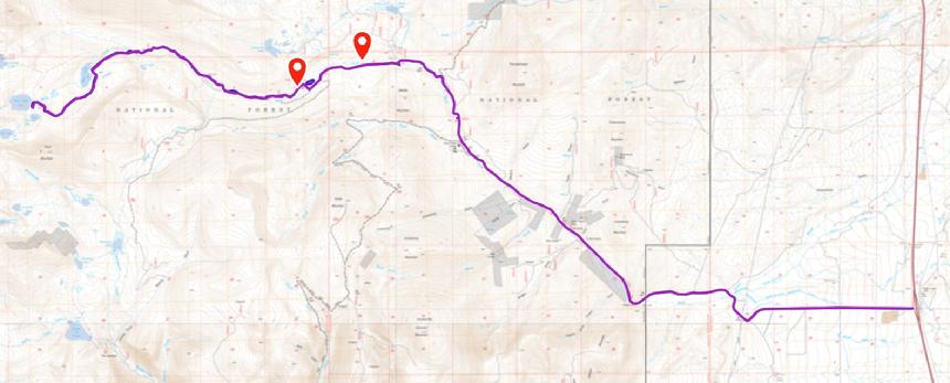
| Birch Creek Road/Trail (to Pear Lake) |
Quick info:
Nearest Town: 13 miles from Dillon Open Dates?: Open May 16th to Dec. 1st
Class: 2.5 (4x4) Length?: 5.3 Miles from trailhead
High-Clearance Required?: YES Wide/Long Vehicles?: No issues
Type?: Same way in & out
|
Note: Officially, it is Birch Creek Road (FSR 98), from the interstate exit to Pear Lake. However, I refer to the 13-mile-long "passenger car" section as Birch Creek Road and the 5.3-mile "primitive road" section as the Birch Creek Trail. I find that easier.
|
ABOUT:
Birch Creek Road (& trail / aka FSR 98) to Pear Lake is a vastly underrated destination trail. It is not tough 4x4 rock crawling, but the scenery around Pear Lake, Boot Lake, and May Lake is simply fantastic.
Pear Lake is at 8679 Feet ASL, and four of the five surrounding peaks are above 10,000 feet, with the fifth above 11,000 feet. NICE!!
There are camping and picnic areas along the southern edge of Pear Lake, suitable for Overlanders, tent campers, or just those looking for a very scenic lunch area.
Down below, Dinner Station Campground is 12 miles from the I15 exit and has eight spots for tents or 16-foot camp trailers. It has potable water and vault toilets. There are also various dispersed camping areas along the main Birch Creek Road.
|
I rated it a Class 2.5 trail instead of simply a Class 2 because I of the creek crossing, and I used 4-Low several times due to the steepness of a couple of sections, but they were doable in 4-Hi. The water crossing can be a little deep during spring runoff.
Birch Creek Road runs 13 miles from the exit to the Birch Creek Trail (officially still FSR98) trailhead. It is a well-maintained road suitable for passenger cars. The "primitive road" or "high clearance TRAIL" section, which goes 5.3 miles from the trailhead to Pear Lake, is suitable for almost any stock 4x4. I saw nothing to cause concerns about longer/wider full-size 4x4 rigs, and you don't need big tires, either.
Along the way to Pear Lake, you will pass through the mining ghost town of Farlin, with some cabins to explore and some historical signs to tell you what happened there. It is along the main (car-accessible) road and sits on Forest Service property.
|
 |
| Pear Lake & Sawtooth Mountain |
|
|
Getting there:
This is an easy destination to get to. We start our trip at I15 Exit 74, about 13 miles north of Dillon. From the exit, turn east onto Birch Creek Road. It is 13 miles to the primative road sign and another 5.3 to the Pear Lake.
The trailhead has a large parking area with plenty of room for tow rigs.
Pro tip: Though the road is good to the trailhead, there is, right off the exit, a good parking area suitable for trailers. It makes for a great group meeting, parking, and air-down/up spot, even if you don't technically "need" to do that until the trailhead.
|
|
(This link can be seen without an account. Just bypass the login screen if you don't have an account...though it will work better if you do.)
|
 |
| Birch Creek full map - GAIA GPS link |
|
|
NOTE: We are simply describing a 4x4 route. We accept no responsibility for your decisions. 4x4 off-roading can be great fun but it can also be dangerous. People can get hurt and vehicles can get stuck and/or damaged. Trail conditions can, do, and will, change at any time. Road conditions may no longer be accurately reflected in this or any trail description. Only you can decide what trails or obstacles your experience and vehicle can safely navigate. When in doubt, turn around. Wheel Safe!!
|
|